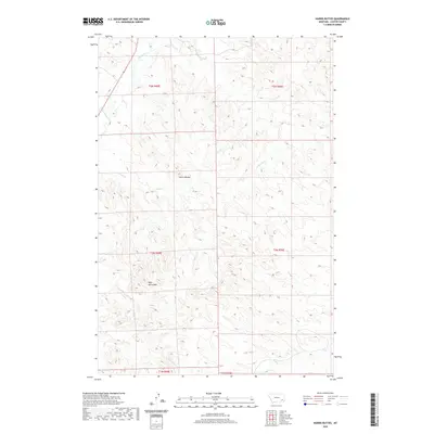
2020 Map of Harris Buttes
USGS Topo · Published 2020About this map
Harris Buttes and Wild Horse Mtn dominate the topography of this Custer County landscape, where the high ground is dissected by an intricate drainage system. This modern survey shows a region defined by its seasonal watercourses, including the northward flow of Pumpkin Cr and Harris Cr. The map reveals the township and range survey lines that still organize this part of Montana, dividing the land into clear sections across ranges such as t2n r49e and t3n r50e. While lacking major settlements, the map provides a look at the network of ranch roads and tracks that navigate between landmarks like Road Cr and Anderson Cr. The distribution of these labels suggests a landscape largely used for grazing and open-range management, where named peaks and creeks serve as the primary navigational anchors.
Find a feature on this map
14 named features on this map. Tap any name to fly to it.
Don’t see what you’re looking for? This feature index may not catch every label — zoom into the map to look around manually.
Map Details
Editions of this 2020 Harris Buttes Map
This is the sole edition of this map. No revisions or reprints were ever made.
Other maps of this area

1953 · Miles City
USGS Topo · 1:250,000

1954 · Ekalaka
USGS Topo · 1:250,000

1956 · Ekalaka
USGS Topo · 1:250,000

1957 · Miles City
USGS Topo · 1:250,000

1958 · Miles City
USGS Topo · 1:250,000

1958 · Ekalaka
USGS Topo · 1:250,000

1965 · Ekalaka
USGS Topo · 1:250,000

1969 · Beebe SW
USGS Topo · 1:24,000

1969 · Miles City Creek
USGS Topo · 1:24,000
1969 · Beebe
USGS Topo · 1:24,000