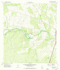
1974 Map of Harris Lake
USGS Topo · Published 1977About this map
The Nueces River winds through the Brush Country of La Salle County, providing the primary hydrological corridor for this South Texas landscape. In the mid-1970s, the area remained dominated by large-scale landholdings and ranching operations, exemplified by the Cochina Ranch situated in the western portion of the quadrangle. Along the river’s course, Harris Lake serves as a notable landmark near the settlement of Harris, reflecting the importance of water management in this arid environment.
Find a feature on this map
10 named features on this map. Tap any name to fly to it.
Don’t see what you’re looking for? This feature index may not catch every label — zoom into the map to look around manually.
Map Details
Editions of this 1974 Harris Lake Map
This is the sole edition of this map. No revisions or reprints were ever made.
Other maps of this area

1927 · Bart
USGS Topo · 1:62,500

1929 · Cotulla
USGS Topo · 1:125,000

1940 · Cotulla
USGS Topo · 1:62,500

1940 · Artesia Wells
USGS Topo · 1:62,500

1942 · Dilley
USGS Topo · 1:62,500

1953 · Crystal City
USGS Topo · 1:250,000

1955 · Crystal City
USGS Topo · 1:250,000

1956 · Woodward
USGS Topo · 1:62,500

1961 · Crystal City
USGS Topo · 1:250,000

1968 · Crystal City
USGS Topo · 1:250,000