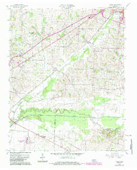
1956 Map of Harris
USGS Topo · Published 1983About this map
The North Fork Obion River meanders across the southern portion of this landscape, forming a natural boundary between Obion and Weakley Counties. The terrain is a network of small agricultural settlements and family-named landmarks connected by the Illinois Central Gulf railroad. In the northeast, South Fulton marks a busy transit point, while smaller communities like Harris, Pierce Station, and Shofner line the rail corridor and rural roads.
Find a feature on this map
26 named features on this map. Tap any name to fly to it.
Don’t see what you’re looking for? This feature index may not catch every label — zoom into the map to look around manually.
Map Details
Editions of this 1956 Harris Map
3 editions found

Other maps of this area

1939 · Hickman
USGS Topo · 1:62,500

1950 · Martin
USGS Topo · 1:24,000

1950 · Rives
USGS Topo · 1:24,000

1951 · Rives
USGS Topo · 1:24,000

1951 · Cayce
USGS Topo · 1:24,000

1952 · Crutchfield
USGS Topo · 1:24,000

1952 · Water Valley
USGS Topo · 1:24,000

1952 · Water Valley
USGS Topo · 1:62,500

1954 · Union City
USGS Topo · 1:24,000

1954 · Hickman
USGS Topo · 1:62,500