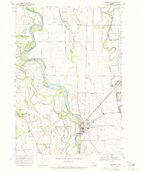
1969 Map of Harrisburg
USGS Topo · Published 1971About this map
Harrisburg serves as the focal point of this late 1960s survey, where the Southern Pacific and Oregon Electric rail lines converge along the east bank of the Willamette River. The landscape is defined by the complex hydrology of the river bottomlands, featuring intricate secondary waterways like Flat Slough and Dodge Island Slough that encircle Ingram Island and Morgan Island.
Find a feature on this map
54 named features on this map. Tap any name to fly to it.
Don’t see what you’re looking for? This feature index may not catch every label — zoom into the map to look around manually.
Map Details
Editions of this 1969 Harrisburg Map
This is the sole edition of this map. No revisions or reprints were ever made.
Other maps of this area

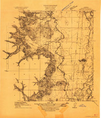
1909 · Harrisburg
USGS Topo · 1:31,680

1909 · Rowland
USGS Topo · 1:31,680

1909 · Elmira
USGS Topo · 1:62,500

1910 · Eugene
USGS Topo · 1:62,500

1911 · Monroe
USGS Topo · 1:31,680
1911 · Inavale
USGS Topo · 1:31,680

1912 · Halsey
USGS Topo · 1:62,500

1922 · Monroe
USGS Topo · 1:62,500
1922 · Elmira
USGS Topo · 1:62,500
1939 · Monroe
USGS Topo · 1:62,500