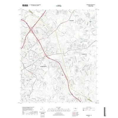
2019 Map of Harrisburg
USGS Topo · Published 2019About this map
The boundary between Cabarrus Co and Mecklenburg Co bisects this late-2010s landscape, where suburban expansion meets significant cultural sites. Much of the western portion is dominated by the Univ of N Carolina at Charlotte campus and the surrounding neighborhoods of Charlotte. The region is notably rich in genealogical sites, including the Alexander Slave Cem and Back Creek Presbyterian Church Cem. To the east, the town of Harrisburg sits near Mc Cachren Field, while the northern reaches include the community of Concord and the site of Roberta Mill. The Rocky River and its tributaries, such as Coddle Creek and Mallard Cr, define the local drainage patterns. This map documents a modern North Carolina landscape where historic burial grounds and institutions like Newell Presbyterian Church Cem remain preserved amidst rapid residential development.
Find a feature on this map
40 named features on this map. Tap any name to fly to it.
Don’t see what you’re looking for? This feature index may not catch every label — zoom into the map to look around manually.
Map Details
Editions of this 2019 Harrisburg Map
This is the sole edition of this map. No revisions or reprints were ever made.
Other maps of this area

1905 · Charlotte
USGS Topo · 1:48,000

1907 · Charlotte
USGS Topo · 1:62,500

1941 · Charlotte
USGS Topo · 1:125,000

1942 · Charlotte
USGS Topo · 1:125,000

1948 · Derita
USGS Topo · 1:24,000

1948 · Charlotte East
USGS Topo · 1:24,000

1949 · Kannapolis
USGS Topo · 1:24,000

1949 · Charlotte East
USGS Topo · 1:24,000

1949 · Harrisburg
USGS Topo · 1:24,000

1949 · Wilgrove
USGS Topo · 1:24,000