
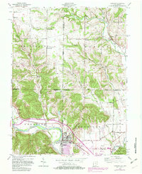
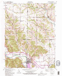
1915 Map of Harrison
USGS Topo · Published 1915About this map
Harrison anchors the southern portion of this survey, situated at the junction of the C. C. C. and St. L. railroad and the Whitewater River. This 1915 advance sheet highlights a dense network of rural infrastructure along the Indiana-Ohio state line, documenting numerous local schoolhouses such as Vannatta School, Davis School, and Edgewood School. The landscape is defined by the winding course of Dry Fork and Indian Creek, which provide the topographical backbone for the townships of Oxford, Reilly, Morgan, and Harrison.
Find a feature on this map
33 named features on this map. Tap any name to fly to it.
Don’t see what you’re looking for? This feature index may not catch every label — zoom into the map to look around manually.
Map Details
Editions of this 1915 Harrison Map
This is the sole edition of this map. No revisions or reprints were ever made.
Historical Maps of Indiana Through Time
5 maps found

Featured Locations
- Brookville, IN
- Reily Township, OH
- Oxford, Oxford Township
- Harrison, Harrison Township
- Saint Leon, Kelso Township