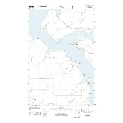
2011 Map of Harrison
USGS Topo · Published 2011About this map
Harrison stands as the primary waterfront settlement where the Coeur d'Alene River meets the expansive lake waters, characterized by its steep-banked shoreline and numerous landings. The landscape is defined by its peninsula-and-cove geography, with significant features like Ch'ach'alqw Landing and Harrison Boat Landing facilitating water access. To the south, the terrain rises into the heights of Shoeffler Butte and Mason Butte, bordering the northern reaches of Heyburn State Park. Local history is embedded in the family-named landmarks such as Talbot Hill and Zehn Hill, which overlook the quiet residential pockets of Peaceful Valley. This era shows a community balanced between its river-mouth origins and its development into a gateway for regional recreation, evidenced by the presence of Camp Easterseal and the Bell Bay Campground along the winding lake road network.
Find a feature on this map
68 named features on this map. Tap any name to fly to it.
Don’t see what you’re looking for? This feature index may not catch every label — zoom into the map to look around manually.
Map Details
Editions of this 2011 Harrison Map
This is the sole edition of this map. No revisions or reprints were ever made.
Other maps of this area

1903 · Rathdrum
USGS Topo · 1:125,000

1955 · Spokane
USGS Topo · 1:250,000

1957 · St. Maries
USGS Topo · 1:62,500

1957 · Plummer
USGS Topo · 1:62,500

1957 · Coeur D'Alene
USGS Topo · 1:62,500

1957 · Lane
USGS Topo · 1:62,500

1958 · Spokane
USGS Topo · 1:250,000

1975 · Plummer NW
USGS Topo · 1:24,000

1975 · Plummer SE
USGS Topo · 1:24,000

1975 · Coeur D'Alene SE
USGS Topo · 1:24,000