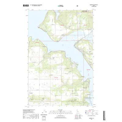
2020 Map of Harrison
USGS Topo · Published 2020About this map
Harrison occupies a prominent position on the eastern shore of Coeur d'Alene Lake, where the Coeur d'Alene River meets the lake's waters. The shoreline is deeply articulated by numerous bays, including Powderhorn Bay, Bell Bay, and Cottonwood Bay, reflecting a landscape dominated by water and wood. To the south, the Saint Joe Wild and Scenic River flows toward Chatcolet Lake, marking the transition into the Coeur d'Alene National Forest. This region preserves a rugged topography defined by landmarks like Talbot Hill and Shoeffler Butte, where early land divisions and the Kootenai-Benewah county line intersect. The settlement pattern remains centered on the water, with Conkling Park and the elevated Harrison Flats serving as focal points for local commerce and residency. Aviation access is noted at the Rock Creek Farm Airport in the southwest, while numerous forest roads provide access to the timbered interior.
Find a feature on this map
135 named features on this map. Tap any name to fly to it.
Don’t see what you’re looking for? This feature index may not catch every label — zoom into the map to look around manually.
Map Details
Editions of this 2020 Harrison Map
This is the sole edition of this map. No revisions or reprints were ever made.
Other maps of this area

1903 · Rathdrum
USGS Topo · 1:125,000

1955 · Spokane
USGS Topo · 1:250,000

1957 · St. Maries
USGS Topo · 1:62,500

1957 · Plummer
USGS Topo · 1:62,500

1957 · Coeur D'Alene
USGS Topo · 1:62,500

1957 · Lane
USGS Topo · 1:62,500

1958 · Spokane
USGS Topo · 1:250,000

1975 · Plummer NW
USGS Topo · 1:24,000

1975 · Plummer SE
USGS Topo · 1:24,000

1975 · Coeur D'Alene SE
USGS Topo · 1:24,000