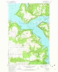
1981 Map of Harrison
USGS Topo · Published 1982About this map
Harrison stands as a focal point on the eastern shore of Coeur d'Alene Lake, serving as a gateway to the diverse waterfront and timberlands of northern Idaho. In this early 1980s landscape, the Union Pacific railroad tracks trace the jagged shoreline, winding past numerous bays such as Powderhorn Bay and Bell Bay. This area illustrates the transition from industrial transport to recreational development, with boat ramps and campgrounds appearing alongside legacy features like the Indian Cemetery and scattered borrow pits. To the south, Heyburn State Park encompasses the marshy convergence of the St Joe River and Chatcolet Lake, while high ground is marked by prominent elevations like Zehm Hill and Mason Butte. The map documents the complex boundary of the Coeur d'Alene Indian Reservation, showing a region defined by its deep relationship with the water and the rugged ridges of the Coeur d'Alene National Forest.
Find a feature on this map
61 named features on this map. Tap any name to fly to it.
Don’t see what you’re looking for? This feature index may not catch every label — zoom into the map to look around manually.
Map Details
Editions of this 1981 Harrison Map
This is the sole edition of this map. No revisions or reprints were ever made.
Other maps of this area

1903 · Rathdrum
USGS Topo · 1:125,000

1955 · Spokane
USGS Topo · 1:250,000

1957 · St. Maries
USGS Topo · 1:62,500

1957 · Plummer
USGS Topo · 1:62,500

1957 · Coeur D'Alene
USGS Topo · 1:62,500

1957 · Lane
USGS Topo · 1:62,500

1958 · Spokane
USGS Topo · 1:250,000

1975 · Plummer NW
USGS Topo · 1:24,000

1975 · Plummer SE
USGS Topo · 1:24,000

1975 · Coeur D'Alene SE
USGS Topo · 1:24,000