
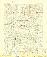
1892 Map of Harrisonville
USGS Topo · Published 1902About this map
Harrisonville serves as the central hub of this Missouri landscape, where the confluence of several early rail lines shaped the settlement patterns of Cass County in the late nineteenth century. The Missouri Pacific Railroad and the Kansas City Clinton and Springfield Railroad cross the terrain, connecting towns such as Pleasant Hill and Lees Summit to the wider regional economy. These transit corridors are flanked by smaller agricultural outposts and post offices, including Daugherty (Eight Mile P. O.) and Lone Jack.
Find a feature on this map
79 named features on this map. Tap any name to fly to it.
Don’t see what you’re looking for? This feature index may not catch every label — zoom into the map to look around manually.
Map Details
Editions of this 1892 Harrisonville Map
2 editions found
Other maps of this area

1885 · Warrensburg
USGS Topo · 1:125,000

1887 · Clinton
USGS Topo · 1:125,000

1887 · Harrisonville
USGS Topo · 1:125,000

1887 · Olathe
USGS Topo · 1:125,000

1887 · Butler
USGS Topo · 1:125,000

1887 · Mound City
USGS Topo · 1:125,000

1887 · Warrensburg
USGS Topo · 1:125,000

1889 · Lexington
USGS Topo · 1:125,000

1890 · Kansas City
USGS Topo · 1:125,000

1893 · Mound City
USGS Topo · 1:125,000