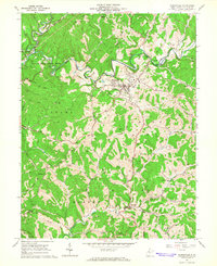
1964 Map of Harrisville
USGS Topo · Published 1966About this map
Harrisville serves as the focal point of this Ritchie County landscape, situated where the ridge-top terrain meets a dense network of watercourses and industrial activity in the mid-1960s. The town is marked by its High School, Masonic Cemetery, and municipal infrastructure like the Filtration Plant and Sewage Disposal. Outside the town center, the map reveals a rugged economy defined by hundreds of Oil Wells and Gas Wells peppering the hillsides, particularly across the Grant and Union districts. The Baltimore and Ohio railroad cuts through the northern section, following the Hughes River and passing through the small community of Cornwallis. This survey captures the transition from remote ridge-top farming to an energy-producing landscape, evidenced by the numerous family-named landmarks like Hulderman Ridge and King Knob, alongside rural spiritual centers such as Riddles Chapel and Spruce Grove Church.
Find a feature on this map
63 named features on this map. Tap any name to fly to it.
Don’t see what you’re looking for? This feature index may not catch every label — zoom into the map to look around manually.
Map Details
Editions of this 1964 Harrisville Map
3 editions found
Other maps of this area

1905 · West Union
USGS Topo · 1:62,500

1906 · Saint Marys
USGS Topo · 1:62,500

1906 · Holbrook
USGS Topo · 1:62,500

1907 · Harrisville
USGS Topo · 1:62,500

1924 · St Marys
USGS Topo · 1:62,500

1924 · Harrisville
USGS Topo · 1:62,500

1924 · West Union
USGS Topo · 1:62,500

1924 · Holbrook
USGS Topo · 1:62,500

1926 · Harrisville
USGS Topo · 1:62,500

1926 · Holbrook
USGS Topo · 1:62,500