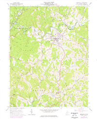
1964 Map of Harrisville
USGS Topo · Published 1977About this map
Harrisville serves as the focal point of this Ritchie County landscape, situated where the terrain transitions from the deep meanders of the North Fork Hughes River to the upland ridges. The town's infrastructure in the mid-1960s includes a High School, a filtration plant, and a golf course, reflecting its role as a local center. Outside the town limits, the geography is defined by an intensive carbon economy, with hundreds of Oil Wells and Gas Wells dotting the hillsides along Hulderman Ridge and Victory Ridge. To the west, the Baltimore and Ohio railroad cuts through the terrain near Cornwallis, passing through a tunnel and a series of river crossings. Small rural communities like Washburn and Hartley are anchored by local landmarks such as Chevaux de Frise Ch and Riddles Chapel, while the developing North Bend State Park preserves the river's winding path.
Find a feature on this map
75 named features on this map. Tap any name to fly to it.
Don’t see what you’re looking for? This feature index may not catch every label — zoom into the map to look around manually.
Map Details
Editions of this 1964 Harrisville Map
3 editions found
Other maps of this area

1905 · West Union
USGS Topo · 1:62,500

1906 · Saint Marys
USGS Topo · 1:62,500

1906 · Holbrook
USGS Topo · 1:62,500

1907 · Harrisville
USGS Topo · 1:62,500

1924 · St Marys
USGS Topo · 1:62,500

1924 · Harrisville
USGS Topo · 1:62,500

1924 · West Union
USGS Topo · 1:62,500

1924 · Holbrook
USGS Topo · 1:62,500

1926 · Harrisville
USGS Topo · 1:62,500

1926 · Holbrook
USGS Topo · 1:62,500