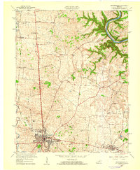
1959 Map of Harrodsburg
USGS Topo · Published 1960About this map
Harrodsburg serves as the focal point of this 1959 revision, where the urban grid expands toward Pioneer Memorial State Park and the historic Spring Hill Cem. The map illustrates a landscape transitioning from the traditional river-oriented economy at Mundys Landing on the Kentucky River to one defined by the Southern railroad corridor and modern road networks. Outlying rural communities like McAfee, Burgin, and Stringtown are well-documented, connected by a web of family-named routes such as Chinn Lane and Bonta Lane. Cultural landmarks of the mid-century era are visible, including a Drive-in Theater and the local High Sch. The topography reveals the deeply incised meanders of the Kentucky River and the numerous springs and runs, like Shawnee Run, that carved the limestone terrain of Mercer County.
Find a feature on this map
51 named features on this map. Tap any name to fly to it.
Don’t see what you’re looking for? This feature index may not catch every label — zoom into the map to look around manually.
Map Details
Editions of this 1959 Harrodsburg Map
This is the sole edition of this map. No revisions or reprints were ever made.
Other maps of this area

1905 · Harrodsburg
USGS Topo · 1:125,000

1950 · Bryantsville
USGS Topo · 1:24,000

1952 · Perryville
USGS Topo · 1:24,000

1952 · Keene
USGS Topo · 1:24,000

1952 · Danville
USGS Topo · 1:24,000

1952 · Harrodsburg
USGS Topo · 1:24,000

1952 · Cornishville
USGS Topo · 1:24,000

1952 · Bryantsville
USGS Topo · 1:24,000

1952 · Salvisa
USGS Topo · 1:24,000

1952 · Mc Brayer
USGS Topo · 1:24,000