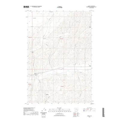
2020 Map of Harsha
USGS Topo · Published 2020About this map
The Touchet River meanders through the southern half of this landscape, carving the fertile Touchet Valley amidst the high, undulating terrain of Walla Walla County. The small settlements of Harsha and Paddock serve as historical anchors for this agricultural region, where the upland reaches of Eureka Flat and the depressions of Dry Hollow define the local topography. This 2020 survey illustrates a complex network of rural infrastructure, including Grant Sanders Rd and Lyons Ferry Rd, which follow the natural contours of the canyons and ridges. Local genealogists and historians can trace family-named thoroughfares such as Pettyjohn Rd, Harvey Shaw Rd, and Donnelly Rd, which speak to the long-standing landownership patterns in this corner of Washington. The map also documents geographic features like Winnett Canyon, providing a clear view of the drainage patterns and land use within the T9N and T10N townships.
Find a feature on this map
23 named features on this map. Tap any name to fly to it.
Don’t see what you’re looking for? This feature index may not catch every label — zoom into the map to look around manually.
Map Details
Editions of this 2020 Harsha Map
This is the sole edition of this map. No revisions or reprints were ever made.
Other maps of this area

1915 · Wallulah
USGS Topo · 1:96,000

1918 · Wallula
USGS Topo · 1:125,000

1919 · Walla Walla
USGS Topo · 1:125,000

1921 · Walla Walla
USGS Topo · 1:125,000

1953 · Walla Walla
USGS Topo · 1:250,000

1958 · Walla Walla
USGS Topo · 1:250,000

1966 · Rulo
USGS Topo · 1:24,000

1966 · Hadley
USGS Topo · 1:24,000

1966 · Valley Grove
USGS Topo · 1:24,000
1966 · Eureka
USGS Topo · 1:24,000