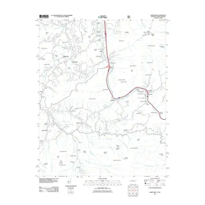
2011 Map of Hartford
USGS Topo · Published 2011About this map
The Pigeon River carves a deep valley through this mountain landscape, following a course that dictates the local infrastructure near the Tennessee-North Carolina border. In the eastern portion of the sheet, the settlement of Hartford serves as a focal point, situated near the Hartford Post Office and Cane Hollow. To the west, the community of Cosby and the Cosby Post Office anchor the landscape near Jenkins Mill. Family history is deeply rooted here, evidenced by numerous small burial grounds such as the Valentine Cemetery, Shultz Cemetery, and McMillan Cemetery scattered among the ridges. High points like Halltop Mountain and the Hall Top Lookout provide vantage points over a complex drainage system including Cosby Creek and Groundhog Creek. The map documents a rural network of roads like Denton Rd and Weaver Branch Rd that connect isolated hollows and coves like Greasy Cove and Laurel Hollow.
Find a feature on this map
168 named features on this map. Tap any name to fly to it.
Don’t see what you’re looking for? This feature index may not catch every label — zoom into the map to look around manually.
Map Details
Editions of this 2011 Hartford Map
This is the sole edition of this map. No revisions or reprints were ever made.
Other maps of this area

1893 · Mt Guyot
USGS Topo · 1:125,000

1912 · Mt Guyot
USGS Topo · 1:125,000

1935 · Newport
USGS Topo · 1:48,000

1935 · Hartford
USGS Topo · 1:24,000

1935 · English Mountain
USGS Topo · 1:48,000

1935 · Neddy Mountain
USGS Topo · 1:24,000

1935 · Clevenger
USGS Topo · 1:24,000

1935 · Jones Cove
USGS Topo · 1:24,000
1936 · Cove Creek Gap
USGS Topo · 1:24,000
1936 · Waterville
USGS Topo · 1:24,000