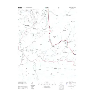
2013 Map of Hartford
USGS Topo · Published 2013About this map
Hartford and Cosby anchor this detailed landscape in Cocke County, where the Pigeon River flows through a corridor of significant islands including Wilson Island, Ryal Island, and Brown Island. The map documents a rural transition between high mountain ridges and valley settlements, marked by agricultural operations like the Kyle Carver Orchards and historic processing sites such as Jenkins Mill and Padgett Mill. The terrain is defined by a series of prominent knobs and gaps, from Denton Knob in the north to the high southern peaks of Mount Cammerer and Three Top Mountain. The settlement pattern follows the drainages of Cosby Cr and Caney Cr, revealing the layout of small communities like Catons Grove, Bluffton, and Allen Grove as they existed in the early 21st century. High-elevation features like Hickorynut Gap and Buzzard Roost overlook the winding paths of Hartford Rd and Shoestring Br.
Find a feature on this map
180 named features on this map. Tap any name to fly to it.
Don’t see what you’re looking for? This feature index may not catch every label — zoom into the map to look around manually.
Map Details
Editions of this 2013 Hartford Map
This is the sole edition of this map. No revisions or reprints were ever made.
Other maps of this area

1893 · Mt Guyot
USGS Topo · 1:125,000

1912 · Mt Guyot
USGS Topo · 1:125,000

1935 · Newport
USGS Topo · 1:48,000

1935 · Hartford
USGS Topo · 1:24,000

1935 · English Mountain
USGS Topo · 1:48,000

1935 · Neddy Mountain
USGS Topo · 1:24,000

1935 · Clevenger
USGS Topo · 1:24,000

1935 · Jones Cove
USGS Topo · 1:24,000
1936 · Cove Creek Gap
USGS Topo · 1:24,000
1936 · Waterville
USGS Topo · 1:24,000