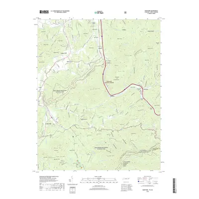
2019 Map of Hartford
USGS Topo · Published 2019About this map
Hartford and Bluffton sit along the winding course of the Pigeon River, a central corridor in this portion of the Blue Ridge where the Tennessee and North Carolina border follows the high ridgeline. The terrain is defined by steep relief, transitioning from the lower elevations of Catons Grove and Allen Grove up to the high peaks of Mt Cammerer and Round Mtn. A significant portion of the landscape is protected within the Great Smoky Mountains National Park and the Cherokee National Forest, preserving a dense network of mountain watercourses like Bogard Creek and Cosby Creek. The area's settled history is visible through a scattered distribution of family burial grounds and former industrial sites, including Sallie Sutton Cem, McMillan Cem, and the historic locations of Jenkins Mill and Padgett Mill. The Appalachian National Scenic Trail winds across the southeastern peaks, tracing the divide between Cocke Co and Haywood Co.
Find a feature on this map
116 named features on this map. Tap any name to fly to it.
Don’t see what you’re looking for? This feature index may not catch every label — zoom into the map to look around manually.
Map Details
Editions of this 2019 Hartford Map
This is the sole edition of this map. No revisions or reprints were ever made.
Other maps of this area

1893 · Mt Guyot
USGS Topo · 1:125,000

1912 · Mt Guyot
USGS Topo · 1:125,000

1935 · Newport
USGS Topo · 1:48,000

1935 · Hartford
USGS Topo · 1:24,000

1935 · English Mountain
USGS Topo · 1:48,000

1935 · Neddy Mountain
USGS Topo · 1:24,000

1935 · Clevenger
USGS Topo · 1:24,000

1935 · Jones Cove
USGS Topo · 1:24,000
1936 · Cove Creek Gap
USGS Topo · 1:24,000
1936 · Waterville
USGS Topo · 1:24,000