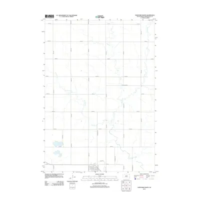
2012 Map of Hartford North
USGS Topo · Published 2012About this map
Skunk Cr and its tributaries define the drainage patterns of this rural landscape north of Hartford at the start of the 2010s. The map illustrates a rigid sectional grid of gravel roads and section lines, including 464th Ave and 254th St, which partition the agricultural terrain. The hydrology is dominated by the meandering W Br Skunk Cr and the presence of Scotts Slough in the southwest, indicating the low-lying, water-rich nature of this part of Minnehaha County. Near the southern boundary, the transition from open farmland to a more organized residential street plan is evident with names like Par Tee Dr and N Main Ave, marking the northward expansion of the local community into the surrounding township.
Find a feature on this map
35 named features on this map. Tap any name to fly to it.
Don’t see what you’re looking for? This feature index may not catch every label — zoom into the map to look around manually.
Map Details
Editions of this 2012 Hartford North Map
This is the sole edition of this map. No revisions or reprints were ever made.
Other maps of this area

1955 · Sioux Falls
USGS Topo · 1:250,000

1958 · Sioux Falls
USGS Topo · 1:250,000

1962 · Colton SE
USGS Topo · 1:24,000

1962 · Hartford South
USGS Topo · 1:24,000

1962 · Hartford North
USGS Topo · 1:24,000

1962 · Sioux Falls West
USGS Topo · 1:24,000

1962 · Crooks
USGS Topo · 1:24,000

1964 · Grass Lake
USGS Topo · 1:24,000

1964 · Humboldt
USGS Topo · 1:24,000
1968 · Colton
USGS Topo · 1:24,000