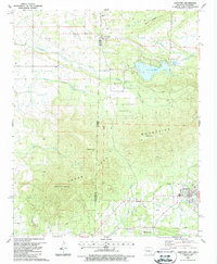
1987 Map of Hartford
USGS Topo · Published 1988About this map
The Indian Treaty Boundary and the Oklahoma-Arkansas state line slice through this 1980s landscape, where the town of Hartford serves as a local hub near the base of the Sugar Loaf Mountains. The map reveals a region defined by its industrial and agricultural history, marked by numerous shale pits and an old railroad grade that once connected these border communities. Resource extraction and rural life converge here, with Slaytonville and West Hartford positioned along the western edge, while Sugar Loaf Lake and a fish hatchery provide distinct landmarks in the terrain. Genealogists will find a wealth of specific local data, including several small burial grounds such as Red Yard Cem, Begum Cem, and Pleasant Valley Cem, alongside the New Providence Ch. High points like Midland Peak and Oklahoma Peak dominate the southern relief, overlooking a network of creeks including Riddle Creek and Gap Creek.
Find a feature on this map
33 named features on this map. Tap any name to fly to it.
Don’t see what you’re looking for? This feature index may not catch every label — zoom into the map to look around manually.
Map Details
Editions of this 1987 Hartford Map
This is the sole edition of this map. No revisions or reprints were ever made.
Other maps of this area

1887 · Poteau Mountain #2
USGS Topo · 1:62,500

1887 · Greenwood
USGS Topo · 1:62,500

1890 · Fort Smith
USGS Topo · 1:125,000

1890 · Poteau Mountain
USGS Topo · 1:125,000

1899 · Poteau Mountain
USGS Topo · 1:125,000

1900 · Sallisaw
USGS Topo · 1:125,000

1900 · Winding Stair
USGS Topo · 1:125,000

1909 · Winding Stair
USGS Topo · 1:125,000

1911 · Sallisaw
USGS Topo · 1:125,000

1943 · Fort Smith
USGS Topo · 1:125,000