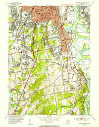
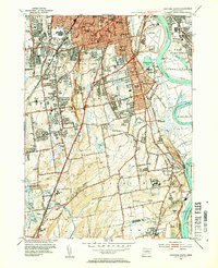
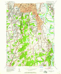
1952 Map of Hartford South
USGS Topo · Published 1954About this map
Hartford and its southern suburbs appear at a moment of significant mid-century expansion along the Connecticut River. This 1952 revision, based on surveys from the early 1940s, shows the transition from the densely packed urban blocks of the city center to the emerging post-war residential patterns in Wethersfield and Newington. Aviation is a central theme of the landscape, with both Brainard Aviation Field and Rentschler Airport established as major infrastructure points near the riverbanks. The map also highlights the specialized institutions of the era, including the State Institute For Blind, State Prison, and Cedar Crest Sanatorium. For local historians, the detailed rendering of neighborhood schools like Bulkeley High Sch and Charter Oak Sch, alongside the sprawling Cedar Hill Cemetery, provides a granular view of the civic and social geography of central Connecticut before the full arrival of the interstate highway system.
Find a feature on this map
96 named features on this map. Tap any name to fly to it.
Don’t see what you’re looking for? This feature index may not catch every label — zoom into the map to look around manually.
Map Details
Editions of this 1952 Hartford South Map
4 editions found

Other maps of this area

1892 · Hartford
USGS Topo · 1:62,500

1892 · Meriden
USGS Topo · 1:62,500

1892 · Granby
USGS Topo · 1:62,500

1893 · Middletown
USGS Topo · 1:62,500

1893 · Meriden
USGS Topo · 1:62,500

1906 · Farmington
USGS Topo · 1:125,000

1928 · Cromwell
USGS Topo · 1:24,000

1928 · Windsor
USGS Topo · 1:24,000

1928 · Glastonbury
USGS Topo · 1:24,000

1928 · Manchester
USGS Topo · 1:24,000