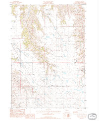
1983 Map of Hartley
USGS Topo · Published 1984About this map
The small community of Hartley serves as the hub of this rural landscape in western South Dakota during the early 1980s. The settlement pattern is defined by widely spaced family operations, including the Radway Ranch, Hanrahan Ranch, and Jetter Bros Ranch, reflecting a deep history of cattle ranching in the region. Education for the local ranching families was centered at the Cheyenne Sch, situated near the confluence of Council Bear Draw and other seasonal drainages.
Find a feature on this map
18 named features on this map. Tap any name to fly to it.
Don’t see what you’re looking for? This feature index may not catch every label — zoom into the map to look around manually.
Map Details
Editions of this 1983 Hartley Map
This is the sole edition of this map. No revisions or reprints were ever made.
Other maps of this area

1954 · Pierre
USGS Topo · 1:250,000

1955 · Bridger
USGS Topo · 1:24,000

1955 · Rattlesnake Lake SW
USGS Topo · 1:24,000

1955 · Bridger SE
USGS Topo · 1:24,000

1955 · Hilland NW
USGS Topo · 1:24,000

1958 · Pierre
USGS Topo · 1:250,000

1983 · Post Ranch
USGS Topo · 1:24,000

1983 · Philip
USGS Topo · 1:100,000

1983 · Hilland
USGS Topo · 1:24,000

1983 · Milesville
USGS Topo · 1:24,000