
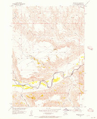
1955 Map of Bridger SE
USGS Topo · Published 1956About this map
The Cheyenne River carves a winding path through this western South Dakota landscape, serving as a natural boundary between Ziebach and Haakon counties. The river corridor is flanked by a complex network of ephemeral drainages and springs that supported the region's ranching economy in the mid-1950s. Water sources like Black Bull Spring, Jackson Spring, and Hold Spring are critical landmarks in this semi-arid terrain, often situated near cattle-raising operations such as the Bull Ranch.
Find a feature on this map
21 named features on this map. Tap any name to fly to it.
Don’t see what you’re looking for? This feature index may not catch every label — zoom into the map to look around manually.
Map Details
Editions of this 1955 Bridger SE Map
2 editions found
Other maps of this area

1954 · Pierre
USGS Topo · 1:250,000

1955 · Bridger
USGS Topo · 1:24,000

1955 · Rattlesnake Lake SW
USGS Topo · 1:24,000

1955 · Rattlesnake Lake
USGS Topo · 1:24,000

1955 · Hilland NW
USGS Topo · 1:24,000

1958 · Pierre
USGS Topo · 1:250,000

1982 · Dead Horse Draw
USGS Topo · 1:24,000

1982 · Bridger NE
USGS Topo · 1:24,000

1983 · Philip
USGS Topo · 1:100,000
1983 · Hartley
USGS Topo · 1:24,000