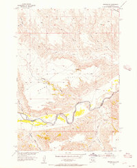
1955 Map of Bridger SW
USGS Topo · Published 1956About this map
The Cheyenne River winds through this mid-century landscape, marking a significant transition between Ziebach and Haakon Counties. This 1955 survey illustrates a rugged drainage system where numerous draws, such as Moon Draw and Clayton Draw, feed into larger tributaries like Bull Creek and Council Bear Creek. The presence of the Reservation Boundary along the river highlights the jurisdictional divisions of the period, while the isolated Bull Ranch stands as the primary human settlement in an area dominated by cattle ranching and sparse water sources.
Find a feature on this map
21 named features on this map. Tap any name to fly to it.
Don’t see what you’re looking for? This feature index may not catch every label — zoom into the map to look around manually.
Map Details
Editions of this 1955 Bridger SW Map
2 editions found
Other maps of this area

1954 · Pierre
USGS Topo · 1:250,000

1955 · Bridger
USGS Topo · 1:24,000

1955 · Rattlesnake Lake SW
USGS Topo · 1:24,000

1955 · Rattlesnake Lake
USGS Topo · 1:24,000

1955 · Bridger SE
USGS Topo · 1:24,000

1955 · Hilland NW
USGS Topo · 1:24,000

1958 · Pierre
USGS Topo · 1:250,000

1982 · Dead Horse Draw
USGS Topo · 1:24,000

1982 · Bridger NE
USGS Topo · 1:24,000

1983 · Philip
USGS Topo · 1:100,000