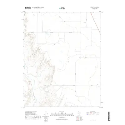
2019 Map of Hartley SW
USGS Topo · Published 2019About this map
Hartley Cem sits on the high plains of the Texas Panhandle, marking a site of local genealogical interest in this largely agricultural landscape. The terrain is defined by the dramatic break of the High Plains as it drops into the drainage of Rita Blanca Cr, creating a complex system of draws and breaks that contrast with the flat tableland above. A sparse network of ranch and county roads, such as Co Rd N and Ranch Rd 998, reveals the large-scale landholdings characteristic of this region. The presence of US Route 385 in the northeast corner provides a modern transit link across the cattle country, while the more remote sections near Co Rd T and Co Rd Y remain dominated by the natural topography of the creek basin.
Find a feature on this map
14 named features on this map. Tap any name to fly to it.
Don’t see what you’re looking for? This feature index may not catch every label — zoom into the map to look around manually.
Map Details
Editions of this 2019 Hartley SW Map
This is the sole edition of this map. No revisions or reprints were ever made.
Other maps of this area

1954 · Tucumcari
USGS Topo · 1:250,000

1958 · Tucumcari
USGS Topo · 1:250,000

1963 · Hartley SE
USGS Topo · 1:24,000

1963 · Hartley NE
USGS Topo · 1:24,000

1971 · Proctor Ranch
USGS Topo · 1:24,000

1971 · Channing NW
USGS Topo · 1:24,000
1971 · Channing
USGS Topo · 1:24,000

1972 · Hartley SW
USGS Topo · 1:24,000

1973 · Pardue Camp
USGS Topo · 1:24,000

1973 · Hartley
USGS Topo · 1:24,000