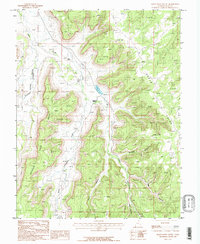
1987 Map of Harts Point South
USGS Topo · Published 1987About this map
Dugout Ranch serves as a primary human landmark in this high-desert landscape of San Juan County, where deep drainages like Indian Creek and North Cottonwood Creek carve through the sandstone. The terrain is defined by massive plateau features such as Harts Point and the isolated formation known as The Island. Evidence of geological exploration and resource extraction is scattered across the topography, particularly in the western sections where Mine Shafts and multiple Adits appear near the winding path of Lavender Creek. The network of 4wd tracks suggests a region where movement follows the natural contours of the canyon floors and mesa tops. Surveyors in the 1980s documented a complex system of tributary canyons, including Donnelly Canyon and Shay Canyon, which funnel toward the major creek beds that dominate the local drainage pattern.
Find a feature on this map
19 named features on this map. Tap any name to fly to it.
Don’t see what you’re looking for? This feature index may not catch every label — zoom into the map to look around manually.
Map Details
Editions of this 1987 Harts Point South Map
This is the sole edition of this map. No revisions or reprints were ever made.
Other maps of this area

1885 · La Sal
USGS Topo · 1:250,000

1886 · Abajo
USGS Topo · 1:250,000

1892 · Abajo
USGS Topo · 1:250,000

1893 · Abajo
USGS Topo · 1:250,000

1935 · Elk Ridge
USGS Topo · 1:96,000

1940 · Elk Ridge
USGS Topo · 1:125,000

1954 · Elk Ridge 1 NW
USGS Topo · 1:24,000

1954 · Elk Ridge 1 NE
USGS Topo · 1:24,000

1954 · Carlisle 4 SW
USGS Topo · 1:24,000

1954 · Mt Peale 3 NW
USGS Topo · 1:24,000