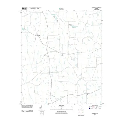
2011 Map of Hartsfield
USGS Topo · Published 2011About this map
Hartsfield and the surrounding agricultural lands of Colquitt County are defined by a complex network of tributaries feeding the Little Ochlockonee River. This landscape is characterized by its numerous small branches and creeks, such as Watery Branch, Slocumb Branch, and Big Branch, which crisscross a terrain dotted with dozens of small lakes and ponds. The community centers around the Hartsfield Post Office, while the smaller settlements of Bay and Center Hill anchor the eastern and southern reaches of the map. Significant water management is evident through the presence of features like Moss Lake Dam, Mims Millpond, and the Bridge Creek Structure Number 83 Dam. Local history is preserved at the Bridge Creek Cemetery, situated near the confluence of several rural routes. The infrastructure is primarily composed of local roads named for prominent families, including Dale Demott Rd, Walter Norman Rd, and Tom Jones Rd, alongside the specialized Emory Carlton Airport.
Find a feature on this map
65 named features on this map. Tap any name to fly to it.
Don’t see what you’re looking for? This feature index may not catch every label — zoom into the map to look around manually.
Map Details
Editions of this 2011 Hartsfield Map
This is the sole edition of this map. No revisions or reprints were ever made.
Other maps of this area

1953 · Dothan
USGS Topo · 1:250,000

1953 · Waycross
USGS Topo · 1:250,000

1954 · Dothan
USGS Topo · 1:250,000

1955 · Dothan
USGS Topo · 1:250,000

1956 · Baconton
USGS Topo · 1:62,500

1956 · Doerun
USGS Topo · 1:62,500

1958 · Waycross
USGS Topo · 1:250,000

1971 · Meigs
USGS Topo · 1:24,000

1971 · Cotton
USGS Topo · 1:24,000
1974 · Doerun
USGS Topo · 1:24,000