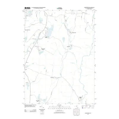
2013 Map of Hartwood
USGS Topo · Published 2013About this map
The Neversink River carves through the eastern portion of this Sullivan County landscape, featuring notable landmarks such as High Falls and Denton Falls. This early 21st-century documentation illustrates a geography defined by private recreational enclaves and numerous water bodies. Several named settlements and community hubs appear, including Saint Josephs, Philwold, and Hartwood. The area's legacy of conservation and organized recreation is evident in the presence of Merriewold Park, Hartwood Club, and Camp Forestburg. Local history researchers can identify established burial grounds like Saint Thomas Cem and Forestburg Cem situated along the western transport corridors. The landscape is heavily saturated with ponds and lakes, from the northern Sackett Lake to the southern Hemlock Lake, connected by a network of drainage ways like the Bush Kill.
Find a feature on this map
83 named features on this map. Tap any name to fly to it.
Don’t see what you’re looking for? This feature index may not catch every label — zoom into the map to look around manually.
Map Details
Editions of this 2013 Hartwood Map
This is the sole edition of this map. No revisions or reprints were ever made.
Other maps of this area

1906 · Port Jervis
USGS Topo · 1:62,500

1908 · Port Jervis
USGS Topo · 1:62,500

1909 · Monticello
USGS Topo · 1:62,500

1911 · Monticello
USGS Topo · 1:62,500

1913 · Milford
USGS Topo · 1:62,500

1915 · Milford
USGS Topo · 1:62,500

1922 · White Lake
USGS Topo · 1:62,500

1942 · White Lake
USGS Topo · 1:62,500

1942 · Port Jervis North
USGS Topo · 1:24,000
1942 · Otisville
USGS Topo · 1:24,000