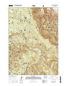
2017 Map of Harvey Creek
USGS Topo · Published 2017About this map
Winter Ridge dominates the northern reaches of this high-elevation landscape, overlooking the drainages of the Sycan River and the S Fork Sycan River. Within the boundaries of the Fremont National Forest, the map reveals a remote area defined by timber and livestock heritage, exemplified by the location of Kates Dairy near Government Harvey Pass. The terrain is characterized by broad flats like Bennett Flat and Harvey Flat, which contrast with the rising elevations of Taylor Buttes. A complex network of Forest Service roads and snowmobile routes, such as the Hadley Snowmobile path, indicates the modern dual use of the land for resource management and recreation. The mapping of numerous water sources, including Cold Spring, Currier Spring, and Hogwallow Spring, provides essential data for those studying the hydrology and land-use history of this corner of Lake County.
Find a feature on this map
86 named features on this map. Tap any name to fly to it.
Don’t see what you’re looking for? This feature index may not catch every label — zoom into the map to look around manually.
Map Details
Editions of this 2017 Harvey Creek Map
This is the sole edition of this map. No revisions or reprints were ever made.
Other maps of this area

1955 · Klamath Falls
USGS Topo · 1:250,000

1958 · Klamath Falls
USGS Topo · 1:250,000

1966 · Shake Butte
USGS Topo · 1:24,000

1966 · Slide Mtn
USGS Topo · 1:24,000

1966 · Sandhill Crossing
USGS Topo · 1:24,000

1966 · Harvey Creek
USGS Topo · 1:24,000

1966 · Fremont Point
USGS Topo · 1:24,000

1966 · Coffeepot Creek
USGS Topo · 1:24,000

1966 · Pole Butte
USGS Topo · 1:24,000

1966 · Lee Thomas Crossing
USGS Topo · 1:24,000