
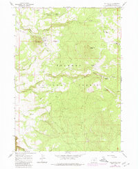
1966 Map of Pole Butte
USGS Topo · Published 1968About this map
Fremont National Forest dominates the landscape of this Lake County region in the mid-1960s, revealing a landscape defined by timber extraction and upland water management. The presence of a Logging Railroad winding through the northern sections near Pole Butte underscores the industrial activity of the era, connecting remote sites like Camp 9 to the broader regional economy. This network of rails and unimproved roads provided the necessary infrastructure for hauling timber out of high elevations like Timber Fall Butte.
Find a feature on this map
25 named features on this map. Tap any name to fly to it.
Don’t see what you’re looking for? This feature index may not catch every label — zoom into the map to look around manually.
Map Details
Editions of this 1966 Pole Butte Map
2 editions found
Other maps of this area

1889 · Klamath
USGS Topo · 1:250,000

1894 · Klamath
USGS Topo · 1:250,000

1955 · Klamath Falls
USGS Topo · 1:250,000

1958 · Klamath Falls
USGS Topo · 1:250,000

1960 · Riverbed Butte
USGS Topo · 1:62,500

1960 · Sycan Marsh
USGS Topo · 1:62,500

1966 · Summer Lake
USGS Topo · 1:24,000

1966 · Shake Butte
USGS Topo · 1:24,000

1966 · Harvey Creek
USGS Topo · 1:24,000

1966 · Fremont Point
USGS Topo · 1:24,000