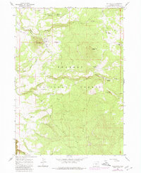
1966 Map of Pole Butte
USGS Topo · Published 1980About this map
Fremont National Forest dominates this mid-century landscape within Lake County, revealing a specialized timber and infrastructure network. The map centers on the Logging Railroad winding near Pole Butte, where a Cinder Pit and Camp 9 suggest active forest management and resource extraction. Water management is a defining feature of this high-elevation terrain, anchored by the Puddle Spring Work Center and a dense system of springs including Picketpin Spring, Picture Tree Springs, and Chocktoot Spring.
Find a feature on this map
27 named features on this map. Tap any name to fly to it.
Don’t see what you’re looking for? This feature index may not catch every label — zoom into the map to look around manually.
Map Details
Editions of this 1966 Pole Butte Map
2 editions found

Other maps of this area

1889 · Klamath
USGS Topo · 1:250,000

1894 · Klamath
USGS Topo · 1:250,000

1955 · Klamath Falls
USGS Topo · 1:250,000

1958 · Klamath Falls
USGS Topo · 1:250,000

1960 · Riverbed Butte
USGS Topo · 1:62,500

1960 · Sycan Marsh
USGS Topo · 1:62,500

1966 · Summer Lake
USGS Topo · 1:24,000

1966 · Shake Butte
USGS Topo · 1:24,000

1966 · Harvey Creek
USGS Topo · 1:24,000

1966 · Fremont Point
USGS Topo · 1:24,000