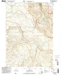
2004 Map of Harvey Creek
USGS Topo · Published 2007About this map
Winter Ridge dominates the skyline of this section of the Fremont National Forest, providing a dramatic backdrop for the headwaters of the Sycan River. The topography of the early 2000s shows a landscape defined by significant elevation changes, from the plateau of Harvey Flat to the descent into the river valley. The region is marked by its recreational and administrative history, featuring the Skull Creek Work Center and the Snow Cabin shelter. Navigation through these woods is traced by the Fremont National Recreation Trail and the Hanan Trail, while the Outback Byway skirts the northern edge. Evidence of historical land use appears at the Prospect near School Creek and the named livestock location at Kates Dairy, showing how the timber and range resources were managed and accessed at the turn of the 21st century.
Find a feature on this map
53 named features on this map. Tap any name to fly to it.
Don’t see what you’re looking for? This feature index may not catch every label — zoom into the map to look around manually.
Map Details
Editions of this 2004 Harvey Creek Map
This is the sole edition of this map. No revisions or reprints were ever made.
Other maps of this area

1955 · Klamath Falls
USGS Topo · 1:250,000

1958 · Klamath Falls
USGS Topo · 1:250,000

1966 · Shake Butte
USGS Topo · 1:24,000

1966 · Slide Mtn
USGS Topo · 1:24,000

1966 · Sandhill Crossing
USGS Topo · 1:24,000

1966 · Harvey Creek
USGS Topo · 1:24,000

1966 · Fremont Point
USGS Topo · 1:24,000

1966 · Coffeepot Creek
USGS Topo · 1:24,000

1966 · Pole Butte
USGS Topo · 1:24,000

1966 · Lee Thomas Crossing
USGS Topo · 1:24,000