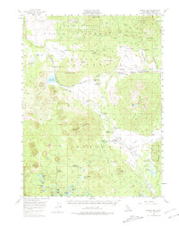
1956 Map of Harvey Mtn
USGS Topo · Published 1981About this map
Blacks Mountain Experimental Forest and the Lassen National Forest dominate this mid-century topography, revealing a landscape defined by timber management and early backcountry outposts. The network of forest service infrastructure is clear, featuring the Bogard Ranger Sta, Stephens Campground, and isolated dwellings like Longs Cabin and Burgess Cabin. These sites, along with the Lodgepole settlement and the Bogard Campground, point to the region's importance for early 20th-century conservation and recreation in the shadow of the Bogard Buttes.
Find a feature on this map
82 named features on this map. Tap any name to fly to it.
Don’t see what you’re looking for? This feature index may not catch every label — zoom into the map to look around manually.
Map Details
Editions of this 1956 Harvey Mtn Map
4 editions found

Other maps of this area

1886 · Honey Lake
USGS Topo · 1:250,000

1886 · Lassen Peak
USGS Topo · 1:250,000

1891 · Honey Lake
USGS Topo · 1:250,000

1892 · Lassen Peak
USGS Topo · 1:250,000

1893 · Honey Lake
USGS Topo · 1:250,000

1894 · Lassen Peak
USGS Topo · 1:250,000

1939 · Halls Flat
USGS Topo · 1:125,000

1955 · Westwood
USGS Topo · 1:62,500

1955 · Westwood
USGS Topo · 1:250,000

1956 · Hayden Hill
USGS Topo · 1:62,500