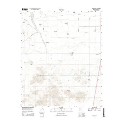
2014 Map of Hassayampa
USGS Topo · Published 2014About this map
Hassayampa and Palo Verde anchor this landscape where the desert floor meets the fertile agriculture of the Buckeye Valley. The Gila River defines the central topography, flanked by significant irrigation works like the Arlington Canal and the Buckeye Canal. These water systems have long supported the scattered settlements and farmsteads found along roads like W Old US-80 and W Salome Hwy. South of the river, the terrain rises sharply into the Buckeye Hills, a stark contrast to the flat valley floor. Prominent landmarks such as Robbins Butte and Powers Butte stand as volcanic sentinels overlooking the floodplains. The map also documents more isolated locales like Dixie and Conger, providing a view of the rural road network and township boundaries such as t1s r5w and t2s r4w that organize this part of Maricopa County.
Find a feature on this map
25 named features on this map. Tap any name to fly to it.
Don’t see what you’re looking for? This feature index may not catch every label — zoom into the map to look around manually.
Map Details
Editions of this 2014 Hassayampa Map
This is the sole edition of this map. No revisions or reprints were ever made.
Other maps of this area

1951 · Cotton Center
USGS Topo · 1:62,500

1951 · Woolsey Peak
USGS Topo · 1:62,500

1954 · Phoenix
USGS Topo · 1:250,000

1957 · Phoenix
USGS Topo · 1:250,000

1957 · Valencia
USGS Topo · 1:24,000

1958 · Phoenix
USGS Topo · 1:250,000

1958 · Buckeye NW
USGS Topo · 1:24,000

1958 · Hassayampa
USGS Topo · 1:24,000

1958 · Buckeye
USGS Topo · 1:24,000

1958 · Buckeye
USGS Topo · 1:62,500