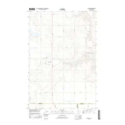
2014 Map of Hastings
USGS Topo · Published 2014About this map
Hastings sits at the heart of this prairie landscape, serving as a focal point for the surrounding agricultural sections of Barnes County. The small settlement is defined by its simple grid including Main St and Oak Ave, with the Spring Creek Cem located just to the northwest. This 2014 survey reveals a region where the natural drainage of Spring Cr and Bear Creek dictates the local geography, creating numerous small wetlands and depressions typical of the North Dakota glaciated plains. A segment of the Sheyenne River Valley Scenic Byway clips the northeastern corner, indicating the area's role in the broader regional tourism and transit network. The map also delineates the meeting of three counties, where Barnes Co, LaMoure Co, and Ransom Co converge at the southern boundary, reflecting the historical township and county surveying lines that organized the Dakota Territory.
Find a feature on this map
27 named features on this map. Tap any name to fly to it.
Don’t see what you’re looking for? This feature index may not catch every label — zoom into the map to look around manually.
Map Details
Editions of this 2014 Hastings Map
This is the sole edition of this map. No revisions or reprints were ever made.
Other maps of this area

1897 · Tower
USGS Topo · 1:125,000

1897 · Eckelson
USGS Topo · 1:125,000

1953 · Jamestown
USGS Topo · 1:250,000

1953 · Fargo
USGS Topo · 1:250,000

1956 · Fargo
USGS Topo · 1:250,000

1956 · Jamestown
USGS Topo · 1:250,000

1967 · Ft. Ransom
USGS Topo · 1:24,000

1967 · Fingal SW
USGS Topo · 1:24,000
1967 · Kathryn
USGS Topo · 1:24,000

1970 · Litchville
USGS Topo · 1:24,000