
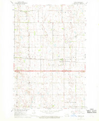
1967 Map of Fingal SW
USGS Topo · Published 1969About this map
The Sheyenne River snakes through the western portion of this Barnes County landscape, carving a deep valley that stands in sharp contrast to the surrounding plateau. Surveyed in the late 1960s as part of the Department of the Interior's Missouri River Basin development program, the map documents a strictly rural township structure organized into sections like Marsh, Cubao, Nelson, and Norma. Local governance and community life are anchored by multiple Townhall locations, while a small Cem and several Gravel Pits suggest the localized nature of early infrastructure and memorial sites. The topographic detail reveals a landscape heavily shaped by water management, evidenced by the Spillway Elev 1318 and numerous glacial depressions across the prairie. This document serves as a clear record of North Dakota’s agrarian geography during the mid-20th century, before more modern industrial shifts.
Find a feature on this map
15 named features on this map. Tap any name to fly to it.
Don’t see what you’re looking for? This feature index may not catch every label — zoom into the map to look around manually.
Map Details
Editions of this 1967 Fingal SW Map
This is the sole edition of this map. No revisions or reprints were ever made.
Other maps of this area

1897 · Tower
USGS Topo · 1:125,000

1897 · Eckelson
USGS Topo · 1:125,000

1953 · Jamestown
USGS Topo · 1:250,000

1953 · Fargo
USGS Topo · 1:250,000

1956 · Fargo
USGS Topo · 1:250,000

1956 · Jamestown
USGS Topo · 1:250,000

1961 · Valley City East
USGS Topo · 1:24,000

1961 · Valley City West
USGS Topo · 1:24,000

1967 · Fingal
USGS Topo · 1:24,000
1967 · Oriska
USGS Topo · 1:24,000