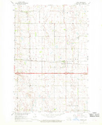
1967 Map of Oriska
USGS Topo · Published 1969About this map
Oriska stands as a focal point in the eastern Barnes County landscape, situated along the vital Northern Pacific railroad corridor. The area shows a transition in transportation infrastructure during the late 1960s, where the established rail line is joined by the developing Interstate 94 corridor, featuring the Cuba Interchange and Oriska Interchange. This survey provides a precise look at the rural township structure, divided into sections such as Alta, Noltimier, and Weimer. Local history is anchored by sites like St Bernards Cem and Oriska Cem, alongside the small settlement of Graves to the north. The presence of a Gravel Pit and a designated highway Rest Area near the interstate reflects the shifting economic and travel patterns of the era as motorized highway transit began to parallel the historic rail routes.
Find a feature on this map
23 named features on this map. Tap any name to fly to it.
Don’t see what you’re looking for? This feature index may not catch every label — zoom into the map to look around manually.
Map Details
Editions of this 1967 Oriska Map
2 editions found
Other maps of this area

1897 · Tower
USGS Topo · 1:125,000

1952 · Grand Forks
USGS Topo · 1:250,000

1953 · Fargo
USGS Topo · 1:250,000

1956 · Fargo
USGS Topo · 1:250,000

1956 · Grand Forks
USGS Topo · 1:250,000

1961 · Valley City East
USGS Topo · 1:24,000

1965 · Tower City SW
USGS Topo · 1:24,000

1966 · Grand Forks
USGS Topo · 1:250,000

1967 · Tower City
USGS Topo · 1:24,000

1967 · Pillsbury SE
USGS Topo · 1:24,000