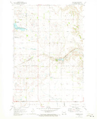
1970 Map of Hastings
USGS Topo · Published 1973About this map
Hastings sits at the crossing of the Burlington Northern railroad and Spring Creek, serving as a central point for this agricultural region on the border of Barnes, La Moure, and Ransom Counties. The landscape is defined by the prairie pothole geography typical of eastern North Dakota, with numerous small water bodies and significant conservation areas. The Stoney Slough National Wildlife Refuge and the Clausen Springs State Game Management Area protect the local wetlands and springs that feed into the larger creek systems. For those tracing local heritage, the Spring Creek Cem is located just north of the rail line, while numerous Gravel Pits scattered across townships like Nelson and Oak Hill indicate the area's geological past and local industry. The map captures the distinct grid of section lines and rural homesteads that shaped the settlement of Skandia and Litchville.
Find a feature on this map
20 named features on this map. Tap any name to fly to it.
Don’t see what you’re looking for? This feature index may not catch every label — zoom into the map to look around manually.
Map Details
Editions of this 1970 Hastings Map
This is the sole edition of this map. No revisions or reprints were ever made.
Other maps of this area

1897 · Tower
USGS Topo · 1:125,000

1897 · Eckelson
USGS Topo · 1:125,000

1953 · Jamestown
USGS Topo · 1:250,000

1953 · Fargo
USGS Topo · 1:250,000

1956 · Fargo
USGS Topo · 1:250,000

1956 · Jamestown
USGS Topo · 1:250,000

1967 · Ft. Ransom
USGS Topo · 1:24,000

1967 · Fingal SW
USGS Topo · 1:24,000
1967 · Kathryn
USGS Topo · 1:24,000

1970 · Litchville
USGS Topo · 1:24,000
Featured Places
- Litchville Township, ND
- Nelson Township, ND
- Oakhill Township, ND
- Spring Creek Township, ND
- Hastings, Spring Creek Township