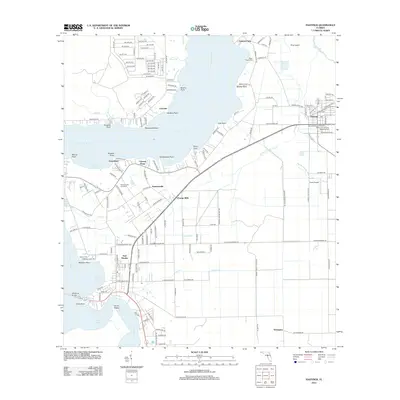
2012 Map of Hastings
USGS Topo · Published 2012About this map
The Saint Johns River defines the western and northern reaches of this landscape, its wide waters punctuated by numerous points such as Verdiere Point and Dancy Point. Agriculture and small-town growth are centered around Hastings, where the street grid expands near the Po and Resthaven Cem and Memorial Park. Further south and west, the settlement of East Palatka sits near the river's bend at Devils Elbow, connected to the opposite shore by the Memorial Bridge. The interior is crisscrossed by drainage and creek systems including Dog Branch and W Run Cracker Br, supporting the rural communities of Orange Mills and Patersonville. Local history is preserved in several sites like the Patersonville Cemetery and Saint Pauls Cem near Federal Point, documenting the long-standing family and community footprints in this riverine region.
Find a feature on this map
170 named features on this map. Tap any name to fly to it.
Don’t see what you’re looking for? This feature index may not catch every label — zoom into the map to look around manually.
Map Details
Editions of this 2012 Hastings Map
This is the sole edition of this map. No revisions or reprints were ever made.
Other maps of this area

1912 · Palatka
USGS Topo · 1:48,000

1915 · Palatka
USGS Topo · 1:62,500

1937 · Elkton
USGS Topo · 1:24,000

1937 · Dinner Island
USGS Topo · 1:48,000

1943 · St. Augustine
USGS Topo · 1:62,500

1943 · Dinner Island
USGS Topo · 1:62,500

1944 · Dinner Island
USGS Topo · 1:62,500

1947 · Bostwick
USGS Topo · 1:50,000

1949 · Bostwick
USGS Topo · 1:24,000
1949 · Riverdale
USGS Topo · 1:24,000