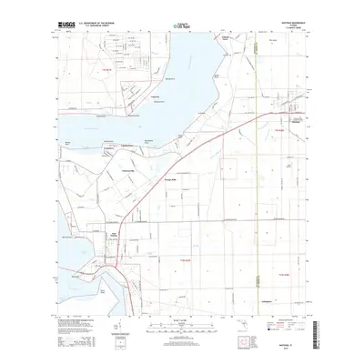
2015 Map of Hastings
USGS Topo · Published 2015About this map
The Saint Johns River defines the western edge of this 2015 survey, where the river's path creates a series of prominent landforms like Devils Elbow, Whetstone Point, and Dancy Point. The interior landscape of Saint Johns and Putnam counties is a mix of agricultural plots and small communities connected by a network of drainage ways including Dog Br and Mill Br. In the eastern section, the town of Hastings serves as a local hub, with its grid-style streets and the Resthaven Cem and Memorial Park clearly delineated.
Find a feature on this map
112 named features on this map. Tap any name to fly to it.
Don’t see what you’re looking for? This feature index may not catch every label — zoom into the map to look around manually.
Map Details
Editions of this 2015 Hastings Map
This is the sole edition of this map. No revisions or reprints were ever made.
Other maps of this area

1912 · Palatka
USGS Topo · 1:48,000

1915 · Palatka
USGS Topo · 1:62,500

1937 · Elkton
USGS Topo · 1:24,000

1937 · Dinner Island
USGS Topo · 1:48,000

1943 · St. Augustine
USGS Topo · 1:62,500

1943 · Dinner Island
USGS Topo · 1:62,500

1944 · Dinner Island
USGS Topo · 1:62,500

1947 · Bostwick
USGS Topo · 1:50,000

1949 · Bostwick
USGS Topo · 1:24,000
1949 · Riverdale
USGS Topo · 1:24,000