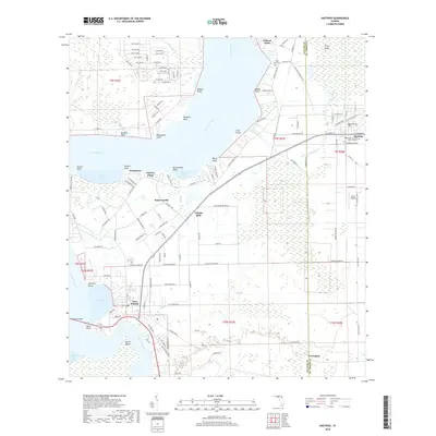
2018 Map of Hastings
USGS Topo · Published 2018About this map
Saint Johns River dominates this landscape along the border of Putnam and Saint Johns counties, where its broad waters are shaped by numerous named points such as Federal Point, Cole Point, and Bodine Point. The eastern shore transitions into agricultural and residential areas, including the town of Hastings, known for its network of avenues and streets, and the village of East Palatka at the south. A mix of rural and developed lands reveals historic footprints like Orange Mills and the small settlement of Yelvington. This survey shows how transport and topography intersect near the water, with features like Memorial Bridge crossing at Harts Point and the winding course of Cracker Br through the lowlands. Local genealogy is supported by the presence of Saint Pauls Cem and Resthaven Cem and Memorial Park, providing clues to the area's established communities.
Find a feature on this map
134 named features on this map. Tap any name to fly to it.
Don’t see what you’re looking for? This feature index may not catch every label — zoom into the map to look around manually.
Map Details
Editions of this 2018 Hastings Map
This is the sole edition of this map. No revisions or reprints were ever made.
Other maps of this area

1912 · Palatka
USGS Topo · 1:48,000

1915 · Palatka
USGS Topo · 1:62,500

1937 · Elkton
USGS Topo · 1:24,000

1937 · Dinner Island
USGS Topo · 1:48,000

1943 · St. Augustine
USGS Topo · 1:62,500

1943 · Dinner Island
USGS Topo · 1:62,500

1944 · Dinner Island
USGS Topo · 1:62,500

1947 · Bostwick
USGS Topo · 1:50,000

1949 · Bostwick
USGS Topo · 1:24,000
1949 · Riverdale
USGS Topo · 1:24,000