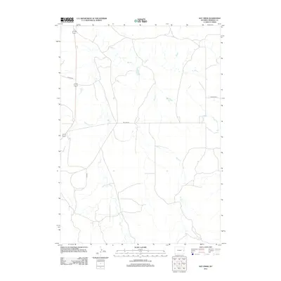
2012 Map of Hat Creek
USGS Topo · Published 2012About this map
The high plains of Niobrara County unfold across this rural landscape, where the seasonal drainage patterns of Sage Cr and Spring Cr dictate the topography. This 2012 survey illustrates a sparsely populated region defined by ranching and historic transit routes. The intersection of modern infrastructure and traditional ranch paths is evident where Hat Creek Rd and Stage Rd navigate the open terrain. In the northwestern corner, Geisinger Rd provides access near the junction with Highway 18 and 85, while Thompson Rd marks a quiet passage to the east. The course of Cottonwood Cr joins the larger creek systems, highlighting the vital role of these limited water sources in the Wyoming cattle country of the early 21st century.
Find a feature on this map
8 named features on this map. Tap any name to fly to it.
Don’t see what you’re looking for? This feature index may not catch every label — zoom into the map to look around manually.
Map Details
Editions of this 2012 Hat Creek Map
This is the sole edition of this map. No revisions or reprints were ever made.
Other maps of this area

1954 · Torrington
USGS Topo · 1:250,000

1955 · Newcastle
USGS Topo · 1:250,000

1958 · Torrington
USGS Topo · 1:250,000

1958 · Newcastle
USGS Topo · 1:250,000

1978 · Shepherds Point
USGS Topo · 1:24,000

1978 · Kirtley SW
USGS Topo · 1:24,000
1978 · South Oat Creek
USGS Topo · 1:24,000

1981 · Telephone Draw
USGS Topo · 1:24,000

1981 · Lusk
USGS Topo · 1:24,000
1981 · Signature Rock
USGS Topo · 1:24,000