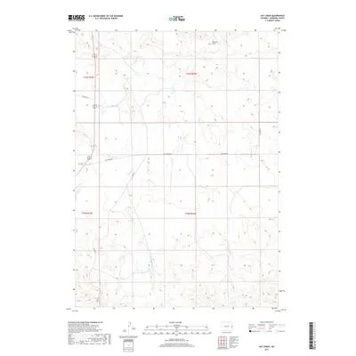
2017 Map of Hat Creek
USGS Topo · Published 2017About this map
Hat Creek serves as the focal point of this Niobrara County landscape, positioned along the edge of the Seaman Hills where the high plains terrain breaks into a network of drainages. The settlement pattern here is defined by early transportation corridors, most notably the historic north-south route of Stage Rd, which intersects with Hat Creek Rd near the community. This 2017 survey by the U.S. Geological Survey documents a region where ranching life and land management are tied to the seasonal flow of Sage Cr, Cottonwood Cr, and Spring Cr. The Public Land Survey System grid, including boundaries for t35n r63w and t34n r62w, provides the framework for these rural holdings. Local navigation is further marked by family-named routes such as Geisinger Rd and Thompson Rd.
Find a feature on this map
13 named features on this map. Tap any name to fly to it.
Don’t see what you’re looking for? This feature index may not catch every label — zoom into the map to look around manually.
Map Details
Editions of this 2017 Hat Creek Map
This is the sole edition of this map. No revisions or reprints were ever made.
Other maps of this area

1954 · Torrington
USGS Topo · 1:250,000

1955 · Newcastle
USGS Topo · 1:250,000

1958 · Torrington
USGS Topo · 1:250,000

1958 · Newcastle
USGS Topo · 1:250,000

1978 · Shepherds Point
USGS Topo · 1:24,000

1978 · Kirtley SW
USGS Topo · 1:24,000
1978 · South Oat Creek
USGS Topo · 1:24,000

1981 · Telephone Draw
USGS Topo · 1:24,000

1981 · Lusk
USGS Topo · 1:24,000
1981 · Signature Rock
USGS Topo · 1:24,000