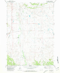
1981 Map of Hat Creek
USGS Topo · Published 1981About this map
The Old Hat Creek Stage Station marks a significant historical point of interest in this Niobrara County landscape, reflecting the region's heritage of frontier transportation. Situated along the corridor of U. S. Route 85, the settlement of Hat Creek serves as a modern anchor in a terrain defined by the striking Seaman Hills to the north and the Hat Creek Breaks to the south. The area is heavily intersected by intermittent waterways including Sage Creek, Spring Creek, and Cottonwood Creek, which have influenced the placement of early ranching and utility infrastructure. Evidence of modern land use is scattered throughout, from the Pipeline and multiple wells to local Landing Strips and industrial Gravel Pits. This survey provides a clear look at the intersection of historical cattle country and mid-century resource extraction, captured during the early 1980s.
Find a feature on this map
18 named features on this map. Tap any name to fly to it.
Don’t see what you’re looking for? This feature index may not catch every label — zoom into the map to look around manually.
Map Details
Editions of this 1981 Hat Creek Map
This is the sole edition of this map. No revisions or reprints were ever made.
Other maps of this area

1954 · Torrington
USGS Topo · 1:250,000

1955 · Newcastle
USGS Topo · 1:250,000

1958 · Torrington
USGS Topo · 1:250,000

1958 · Newcastle
USGS Topo · 1:250,000

1978 · Shepherds Point
USGS Topo · 1:24,000

1978 · Kirtley SW
USGS Topo · 1:24,000
1978 · South Oat Creek
USGS Topo · 1:24,000

1981 · Telephone Draw
USGS Topo · 1:24,000

1981 · Lusk
USGS Topo · 1:24,000
1981 · Signature Rock
USGS Topo · 1:24,000