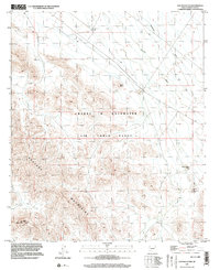
1996 Map of Hat Mountain
USGS Topo · Published 2003About this map
Barry M Goldwater Air Force Range dominates the central landscape of this western Maricopa County survey, indicating the significant military footprint in the Arizona desert during the late twentieth century. The terrain is defined by the prominent Sauceda Mountains, where Hat Mountain stands as a primary landmark in the southwest. A network of ephemeral drainage systems, including Quilotosa Wash and Sauceda Wash, carves through the arid flats and volcanic features like Black Butte. Scattered infrastructure reflects the area's specialized use, with several remote facilities such as an Observation Tower, a Communication Tower, and a Heliport Observation Tower situated among the peaks and washes. The map provides a clear view of the intersection between natural desert topography and the operational requirements of the United States Air Force.
Find a feature on this map
10 named features on this map. Tap any name to fly to it.
Don’t see what you’re looking for? This feature index may not catch every label — zoom into the map to look around manually.
Map Details
Editions of this 1996 Hat Mountain Map
This is the sole edition of this map. No revisions or reprints were ever made.
Other maps of this area

1950 · Theba
USGS Topo · 1:62,500

1951 · Gila Bend
USGS Topo · 1:62,500

1951 · Theba
USGS Topo · 1:62,500

1953 · Ajo
USGS Topo · 1:250,000

1957 · Ajo
USGS Topo · 1:250,000

1958 · Ajo
USGS Topo · 1:250,000

1958 · Midway
USGS Topo · 1:62,500

1958 · Hat Mountain
USGS Topo · 1:62,500

1962 · Ajo
USGS Topo · 1:250,000

1963 · Ajo
USGS Topo · 1:250,000