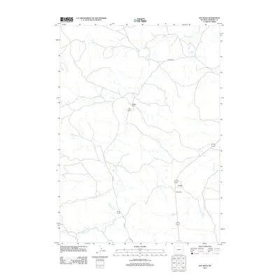
2012 Map of Hat Rock
USGS Topo · Published 2012About this map
Hat Rock and Ship Rock stand as prominent landmarks in this high plains landscape of Niobrara County, where the drainage patterns of Old Woman Cr and Cottonwood Cr define the local topography. This 2012 survey by the U.S. Geological Survey and BLM illustrates a sparsely populated ranching region characterized by named topographic features such as Timber Draw, Hay Draw, and Petts Draw. Local infrastructure is represented by a network of rural routes, including Geisinger Rd and Petts Rd, which provide access to water sources like Darrell Springs. The presence of these named draws and springs indicates the critical role of water management and geography in this arid Wyoming environment, offering a clear view of the land as it was managed at the start of the 2010s.
Find a feature on this map
12 named features on this map. Tap any name to fly to it.
Don’t see what you’re looking for? This feature index may not catch every label — zoom into the map to look around manually.
Map Details
Editions of this 2012 Hat Rock Map
This is the sole edition of this map. No revisions or reprints were ever made.
Other maps of this area

1954 · Torrington
USGS Topo · 1:250,000

1955 · Newcastle
USGS Topo · 1:250,000

1958 · Torrington
USGS Topo · 1:250,000

1958 · Newcastle
USGS Topo · 1:250,000

1981 · Telephone Draw
USGS Topo · 1:24,000

1981 · Lusk
USGS Topo · 1:24,000
1981 · Signature Rock
USGS Topo · 1:24,000
1981 · Rabbit Mountains
USGS Topo · 1:24,000
1981 · Coyote Gap
USGS Topo · 1:24,000

1981 · Manville
USGS Topo · 1:24,000