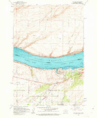
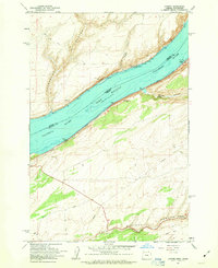
Lake Wallula dominates the center of this survey, marking the flooded landscape created behind the McNary Dam along the Columbia River. The state boundary between Washington and Oregon runs through the center of the lake, separating Benton and Umatilla counties. The map captures a moment of infrastructure development, showing the Spokane Portland and Seattle Railroad hugging the northern shore while the Union Pacific Railroad serves the southern side. On the Oregon shore, Hat Rock State Park and the distinctive Hat Rock formation stand near the water's edge, while the inland areas show a transition to agriculture and industry with various gravel pits and a series of rural roads like West Locust Road and East Progress Road. Conservation efforts are also visible at the Cold Springs National Wildlife Refuge in the southeast.
31 named features on this map. Tap any name to fly to it.
Don’t see what you’re looking for? This feature index may not catch every label — zoom into the map to look around manually.
3 editions found
65 maps found

1916 Coyote Rapids
Benton County, WA

1948 Emerson Nipple
Benton County, WA

1951 Corral Canyon
Benton County, WA

1951 Coyote Rapids
Benton County, WA

1962 Blalock Island
Benton County, WA

1962 Canoe Ridge
Benton County, WA

1962 Crow Butte
Benton County, WA

1962 Paterson
Benton County, WA

1964 Johnson Butte
Benton County, WA

1964 Nine Canyon
Benton County, WA

1965 Badger Mtn
Benton County, WA

1965 Badger Mtn
Benton County, WA

1965 Coyote Rapids
Benton County, WA

1965 Lenzie Ranch
Benton County, WA

1965 Prior Ranch
Benton County, WA

1965 Prosser SE
Benton County, WA

1965 Taylor Canyon
Benton County, WA

1965 Weber Canyon
Benton County, WA

1965 Whitstran
Benton County, WA

1965 Whitstran
Benton County, WA

1965 Whitstran NE
Benton County, WA

1965 Whitstran SE
Benton County, WA

1974 Iowa Flats
Benton County, WA

1974 Maiden Spring
Benton County, WA

1974 Snively Basin
Benton County, WA

1977 Corral Canyon
Benton County, WA

1977 Horn Rapids Dam
Benton County, WA

1977 Snipes Creek
Benton County, WA

1978 Wooden Island
Benton County, WA

1979 Sagebrush Ridge
Benton County, WA

1986 Gable Butte
Benton County, WA

1986 Hanford
Benton County, WA

1986 Riverland
Benton County, WA

1992 Wooden Island
Benton County, WA

1993 Canoe Ridge
Benton County, WA

1993 Crow Butte
Benton County, WA

1993 Paterson
Benton County, WA

1993 West of Paterson
Benton County, WA

2023 Badger Mountain
Benton County, WA

2023 Canoe Ridge
Benton County, WA

2023 Corral Canyon
Benton County, WA

2023 Crow Butte
Benton County, WA

2023 Emerson Nipple
Benton County, WA

2023 Gable Butte
Benton County, WA

2023 Hanford
Benton County, WA

2023 Horn Rapids Dam
Benton County, WA

2023 Iowa Flats
Benton County, WA

2023 Johnson Butte
Benton County, WA

2023 Lenzie Ranch
Benton County, WA

2023 Maiden Spring
Benton County, WA

2023 Nine Canyon
Benton County, WA

2023 Paterson
Benton County, WA

2023 Prior Ranch
Benton County, WA

2023 Prosser SE
Benton County, WA

2023 Riverland
Benton County, WA

2023 Sagebrush Ridge
Benton County, WA

2023 Snipes Creek
Benton County, WA

2023 Snively Basin
Benton County, WA

2023 Taylor Canyon
Benton County, WA

2023 Webber Canyon
Benton County, WA

2023 West of Paterson
Benton County, WA

2023 Whitstran
Benton County, WA

2023 Whitstran NE
Benton County, WA

2023 Whitstran SE
Benton County, WA

2023 Wooded Island
Benton County, WA