
1962 Map of Hat Rock
USGS Topo · Published 1978About this map
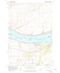
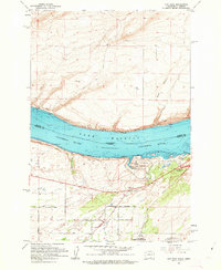
Lake Wallula and the Columbia River dominate this early 1960s landscape, marking the interstate boundary where Washington and Oregon meet. The waterway is a hub of transit and recreation, featuring the distinctive monoliths of Hat Rock and Boat Rock near the shores of Hat Rock State Park. On the northern bank, the Berrian settlement sits along the Spokane Portland and Seattle Railroad, while the southern Oregon side is crisscrossed by the Union Pacific Railroad near River View. A network of rural roads like West Walls Road and East Progress Road serves the surrounding plateaus. The topography is defined by deep cuts such as Rush Canyon and Box Canyon, and the conservation of the local environment is evidenced by the Cold Springs National Wildlife Refuge located at the southern edge of the survey area.
Find a feature on this map
29 named features on this map. Tap any name to fly to it.
Don’t see what you’re looking for? This feature index may not catch every label — zoom into the map to look around manually.
Map Details
Editions of this 1962 Hat Rock Map
3 editions found
Historical Maps of Umatilla Through Time
124 maps found
1962 Hat Rock
Umatilla County, OR

1962 Juniper
Umatilla County, OR

1962 Ordnance
Umatilla County, OR

1962 Stanfield SE
Umatilla County, OR

1963 Big Meadows
Umatilla County, OR

1963 Bingham Springs
Umatilla County, OR

1963 Blalock Mountain
Umatilla County, OR

1963 Meacham Lake
Umatilla County, OR

1963 Peterson Ridge
Umatilla County, OR

1963 Tollgate
Umatilla County, OR

1964 Bowlus Hill
Umatilla County, OR

1964 Duncan
Umatilla County, OR

1964 Gibbon
Umatilla County, OR

1964 Huron
Umatilla County, OR

1964 Thimbleberry Mtn
Umatilla County, OR

1964 Thorn Hollow
Umatilla County, OR

1964 Weston Mountain
Umatilla County, OR

1966 Barnhart
Umatilla County, OR

1966 Cabbage Hill
Umatilla County, OR

1966 Coombs Canyon
Umatilla County, OR

1966 Holdman SE
Umatilla County, OR

1966 Holdman
Umatilla County, OR

1966 Juniper Canyon
Umatilla County, OR

1966 Mc Kay Reservoir
Umatilla County, OR

1966 Ring
Umatilla County, OR

1966 Smeltz
Umatilla County, OR

1966 Table Rock
Umatilla County, OR

1966 Waterman
Umatilla County, OR

1967 Bassey Creek
Umatilla County, OR

1967 Bridge Creek
Umatilla County, OR

1967 Carney Butte
Umatilla County, OR

1967 Granite Meadows
Umatilla County, OR

1967 Lehman Springs
Umatilla County, OR

1967 Nye
Umatilla County, OR

1967 Owens Butte
Umatilla County, OR

1967 Pearson Ridge
Umatilla County, OR

1967 Sevenmile Creek
Umatilla County, OR

1967 Tamarack Gulch
Umatilla County, OR

1967 Tower Mtn
Umatilla County, OR

1967 Ukiah SE
Umatilla County, OR

1968 Echo SE
Umatilla County, OR

1968 Echo SW
Umatilla County, OR

1968 Gurdane
Umatilla County, OR

1968 Nolin
Umatilla County, OR

1968 Service Buttes NW
Umatilla County, OR

1968 Service Buttes
Umatilla County, OR

1968 Vinson
Umatilla County, OR

1969 Deerhorn Creek
Umatilla County, OR

1969 Sugarbowl Creek
Umatilla County, OR

1993 Hat Rock
Umatilla County, OR

1993 Juniper
Umatilla County, OR

1993 Ordnance
Umatilla County, OR

1993 Stanfield SE
Umatilla County, OR

1995 Big Meadows
Umatilla County, OR

1995 Bingham Springs
Umatilla County, OR

1995 Blalock Mountain
Umatilla County, OR

1995 Bridge Creek
Umatilla County, OR

1995 Carney Butte
Umatilla County, OR

1995 Deerhorn Creek
Umatilla County, OR

1995 Duncan
Umatilla County, OR

1995 Gibbon
Umatilla County, OR

1995 Granite Meadows
Umatilla County, OR

1995 Huron
Umatilla County, OR

1995 Lehman Springs
Umatilla County, OR

1995 Meacham Lake
Umatilla County, OR

1995 Owens Butte
Umatilla County, OR

1995 Pearson Ridge
Umatilla County, OR

1995 Sugarbowl Creek
Umatilla County, OR

1995 Tamarack Gulch
Umatilla County, OR

1995 Thimbleberry Mountain
Umatilla County, OR

1995 Tollgate
Umatilla County, OR

1995 Tower Mountain
Umatilla County, OR

1995 Ukiah SE
Umatilla County, OR

1996 Bassey Creek
Umatilla County, OR

1996 Sevenmile Creek
Umatilla County, OR

2023 Barnhart
Umatilla County, OR

2023 Bassey Creek
Umatilla County, OR

2023 Blalock Mountain
Umatilla County, OR

2023 Bowlus Hill
Umatilla County, OR

2023 Cabbage Hill
Umatilla County, OR

2023 Carney Butte
Umatilla County, OR

2023 Coombs Canyon
Umatilla County, OR

2023 Deerhorn Creek
Umatilla County, OR

2023 Duncan
Umatilla County, OR

2023 Gibbon
Umatilla County, OR

2023 Gurdane
Umatilla County, OR

2023 Holdman SE
Umatilla County, OR

2023 Holdman
Umatilla County, OR

2023 Juniper
Umatilla County, OR

2023 Lehman Springs
Umatilla County, OR

2023 Meacham Lake
Umatilla County, OR

2023 Nye
Umatilla County, OR

2023 Owens Butte
Umatilla County, OR

2023 Peterson Ridge
Umatilla County, OR

2023 Sevenmile Creek
Umatilla County, OR

2023 Smeltz
Umatilla County, OR

2023 Stanfield SE
Umatilla County, OR

2023 Sugarbowl Creek
Umatilla County, OR

2023 Table Rock
Umatilla County, OR

2023 Tamarack Gulch
Umatilla County, OR

2023 Thimbleberry Mountain
Umatilla County, OR

2023 Thorn Hollow
Umatilla County, OR

2023 Tower Mountain
Umatilla County, OR

2023 Ukiah SE
Umatilla County, OR

2023 Ward Butte
Umatilla County, OR

2023 Waterman
Umatilla County, OR

2023 Weston Mountain
Umatilla County, OR

2024 Big Meadows
Umatilla County, OR

2024 Bingham Springs
Umatilla County, OR

2024 Bridge Creek
Umatilla County, OR

2024 Echo SE
Umatilla County, OR

2024 Echo SW
Umatilla County, OR

2024 Granite Meadows
Umatilla County, OR

2024 Hat Rock
Umatilla County, OR

2024 Huron
Umatilla County, OR

2024 Juniper Canyon
Umatilla County, OR

2024 McKay Reservoir
Umatilla County, OR

2024 Nolin
Umatilla County, OR

2024 Ordnance
Umatilla County, OR

2024 Pearson Ridge
Umatilla County, OR

2024 Ring
Umatilla County, OR

2024 Service Buttes
Umatilla County, OR

2024 Tollgate
Umatilla County, OR

2024 Vinson
Umatilla County, OR