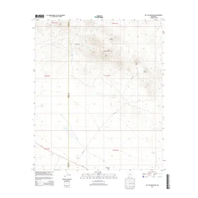
2013 Map of Hat Top Mountain
USGS Topo · Published 2013About this map
Cedar Mountain Range dominates this corner of the High Desert, straddling the border of Grant and Luna Counties. This 2013 survey illustrates a landscape defined by water management in an arid environment, with numerous man-made livestock tanks and catchments scattered across the terrain. Notable among these are CCC Tank, which reflects the infrastructure legacy of the Civilian Conservation Corps, and Railroad Tank, hinting at the historic logistics of the region. High points like Hat Top Mtn, Old Baldy, and Deer Mtn provide prominent landmarks above the draws and canyons. In the southern portion of the quadrangle, NM-9 and CO Road C001 provide the primary transit corridors through the flats, passing near a large seasonal drainage known simply as The Lake. The map serves as a meticulous record of land divisions and topographical features within these remote New Mexico townships.
Find a feature on this map
31 named features on this map. Tap any name to fly to it.
Don’t see what you’re looking for? This feature index may not catch every label — zoom into the map to look around manually.
Map Details
Editions of this 2013 Hat Top Mountain Map
This is the sole edition of this map. No revisions or reprints were ever made.
Other maps of this area

1918 · Hachita
USGS Topo · 1:62,500

1918 · Victorio
USGS Topo · 1:62,500

1954 · Silver City
USGS Topo · 1:250,000

1955 · Douglas
USGS Topo · 1:250,000

1958 · Silver City
USGS Topo · 1:250,000

1959 · Douglas
USGS Topo · 1:250,000

1961 · Douglas
USGS Topo · 1:250,000

1962 · Silver City
USGS Topo · 1:250,000

1963 · Gage SW
USGS Topo · 1:24,000
1963 · Gage SE
USGS Topo · 1:24,000