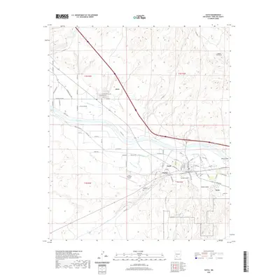
2020 Map of Hatch
USGS Topo · Published 2020About this map
The Rio Grande corridor in Rincon Valley serves as the agricultural and industrial backbone for this section of Doña Ana County. The village of Hatch is the primary hub, surrounded by smaller settlements like Placitas and Rodey, which are linked by an intricate network of irrigation features including the Hatch Canal, Rodey Lateral, and Hatch Drain. This water management system is essential for the valley's productivity, contrasting sharply with the arid slopes of the Caballo Mountains to the northeast.
Find a feature on this map
83 named features on this map. Tap any name to fly to it.
Don’t see what you’re looking for? This feature index may not catch every label — zoom into the map to look around manually.
Map Details
Editions of this 2020 Hatch Map
This is the sole edition of this map. No revisions or reprints were ever made.
Other maps of this area

1955 · Las Cruces
USGS Topo · 1:250,000

1958 · Las Cruces
USGS Topo · 1:250,000

1958 · Arroyo Cuervo
USGS Topo · 1:24,000

1959 · Hatch
USGS Topo · 1:24,000
1959 · Sierra Alta
USGS Topo · 1:24,000
1959 · Souse Springs
USGS Topo · 1:24,000

1959 · Rincon
USGS Topo · 1:24,000

1959 · Upham
USGS Topo · 1:62,500

1961 · Nutt
USGS Topo · 1:62,500

1961 · Garfield
USGS Topo · 1:24,000