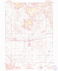
1991 Map of Hatch Mesa
USGS Topo · Published 1991About this map
Horse Mesa and Hatch Mesa dominate this high-desert landscape in eastern Utah, where the terrain transitions from the Gunnison Valley toward the dramatic rising contours of Christmas Ridge. This 1991 provisional survey reveals a territory defined by its aridity and historical transport routes, most notably the Old Railroad Grade that cuts across the central flats near the small settlement of Floy. Scattered Gravel Pits, Prospects, and Drill Holes indicate a history of resource exploration and road-building materials in an area otherwise characterized by ephemeral drainages like Floy Wash and Little Grand Wash. For researchers, the presence of cattle-country markers such as a Corral and remote outposts like Solitude and Browns provides a look at the sparse, utility-focused occupation of this pocket of Grand County before the turn of the millennium.
Find a feature on this map
28 named features on this map. Tap any name to fly to it.
Don’t see what you’re looking for? This feature index may not catch every label — zoom into the map to look around manually.
Map Details
Editions of this 1991 Hatch Mesa Map
This is the sole edition of this map. No revisions or reprints were ever made.
Other maps of this area

1885 · San Rafael
USGS Topo · 1:250,000

1885 · East Tavaputs
USGS Topo · 1:250,000

1885 · La Sal
USGS Topo · 1:250,000

1886 · Price River
USGS Topo · 1:250,000

1896 · Price River
USGS Topo · 1:250,000

1954 · Tidwell 1 NE
USGS Topo · 1:24,000

1954 · Tidwell 1 SE
USGS Topo · 1:24,000

1954 · Green River
USGS Topo · 1:62,500

1956 · Salina
USGS Topo · 1:250,000

1956 · Price
USGS Topo · 1:250,000